The fjords in Norway are world-famous - they feature regularly in travel magazines, are frequently photographed and always a successful addition to travel blogs and social media. Travellers from all over the world have places like Aurlandsfjorden and Geirangerfjorden on their "bucket list", and no visitor can claim to know this country without having experienced the contrast-filled landscape with sheltered fruit orchards and icy glaciers, narrow fjords and magnificent mountains. Whether you're familiar with the fjord counties or have never seen them up close - here are some tips that will take you to the crème-de-la-crème of Norwegian geography.
- 1
Stavanger (Lysefjorden)
Pulpit Rock and Kjeragbolten – Norwegian Icons in Stone

- Περιπέτεια
- Φωτογραφία
Stavanger is only a short distance from Lysefjord, where you'll find some of the country's most iconic rock formations. Of all the sights in the Norwegian mountains, few are more instantly recognisable than Pulpit Rock. This famous plateau with a vertical cliff plunging 600 metres into the fjord is surprisingly easy to access, which means that on nice summer days, the mountain shelf is crowded with hikers. Deeper inland, on the other side of the fjord, the boulder Kjeragbolten hangs in a ravine in the mountains - an ambitious destination, but not at all as neck-breaking as it seems from the popular photo angles. From Stavanger you can join a fjord cruise into the Lysefjord and see these and other sights from the water.
Τοποθεσία: Lysefjorden, Rogaland, Norway
Χάρτης - 2
Voss (between Sognefjord and Hardangerfjord)
Right Between Norway's Longest Fjords

- Φωτογραφία
Closest to the middle of the large western fjords is the village of Voss. It is a worthy destination in itself - especially for extreme sports enthusiasts - and an excellent base for exploring some of the most beautiful parts of both the Sognefjord and the Hardangerfjord. Only three quarters of an hour's drive northeast is Gudvangen and the UNESCO-listed Nærøyfjord. Here you can join a fjord cruise or take a kayak out through the narrow fjord amidst stunning scenery and a culture-rich landscape, including remote farms and some of the country's longest waterfalls. In the other direction, it will take you less than thirty minutes to drive to Granvin in the innermost part of the Hardangerfjord. A little further along the fjord you'll come across fruit orchards and farms and the world-famous Trolltunga in the mountains in Tyssedal.
Τοποθεσία: Voss, Vestland, Norway
Χάρτης - 3
Åndalsnes (Geirangerfjord)
Take the Train or Car Through the Dramatic Landscape
- Φωτογραφία
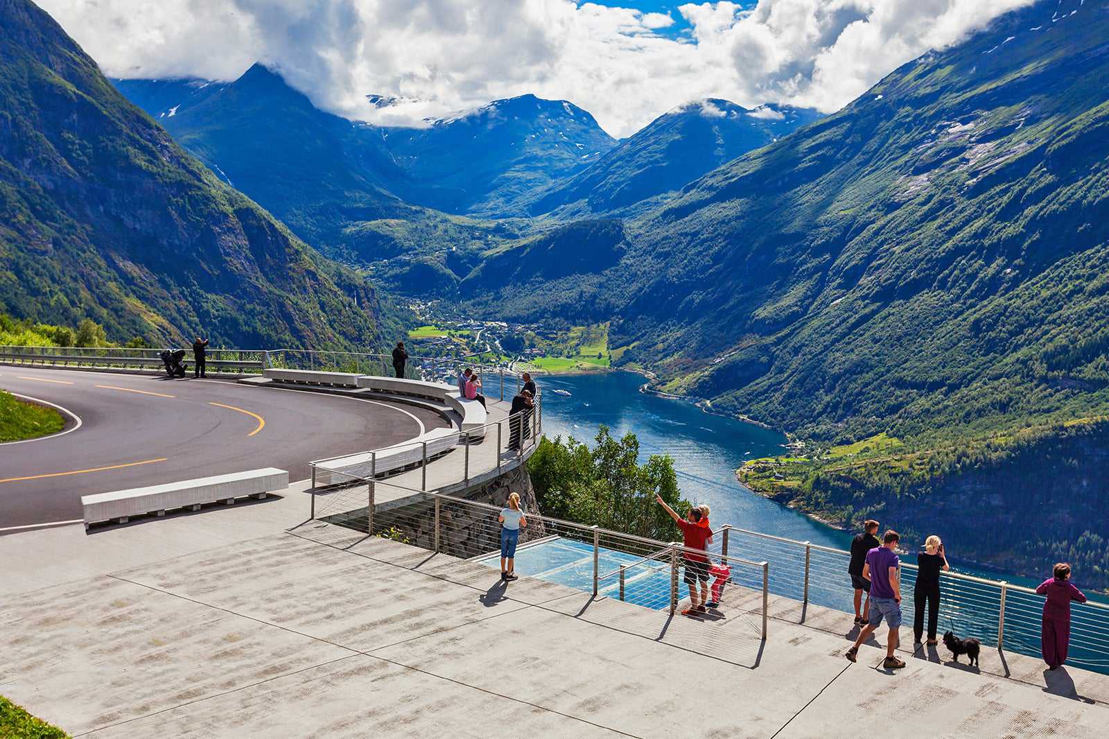
Åndalsnes in the innermost part of the Romsdalsfjord is the terminus for the Rauma line and a hub for traffic in the district and in the heart of one of Norway's most impressive landscapes. Head south into Isterdalen to take the summer road over the mountain to Geiranger, and you will see Trolltindene with the famous Trollveggen. With its 1000 metres of vertical precipice, it has attracted climbers from all over the world for many decades. At the bottom of the valley, the stretch of road known as Trollstigen winds its way through hairpin bends up to the high mountains. Eventually you reach Geiranger and the Geirangerfjord, which with its many cascading waterfalls and impressive viewpoints is the very essence of the Norwegian fjord landscape.
Τοποθεσία: Ålesund, Møre and Romsdal, Norway
Χάρτης - 4
Bodø (Saltfjord)
By the World's Strongest Maelstrom

- Φωτογραφία
The Saltfjord at Bodø is wide and open, and a far cry from the typical fjord landscape that most visitors are used to. However, it has something quite special and spectacular: Saltstraumen. When the tide turns and the water that has flowed into the strait between Saltfjorden and Skjerstadfjorden and back out again, great forces are set in motion, and current vortices occur with a depth of up to five metres. An entire tourist industry has emerged around Saltstraumen, with a museum and accommodation. You can also join a RIB boat and feel the pull and tug of the current as you whip across the water. As well as Saltstraumen, Bodø and the surrounding area can offer you midnight sun in the summer and a chance of northern lights in winter, not to mention a pleasant urban area that is worth a trip in itself.
Τοποθεσία: Bodø, Nordland, Norway
Χάρτης - 5
Flåm (Aurlandsfjord)
Fjord-Norway in Brief

- Φωτογραφία
The small town of Flåm in the innermost part of the Aurlandsfjord is not a big spot, but receives tens of thousands of visitors every year, and it's easy to see why. One reason is the Aurlandsfjorden fjord arm on the south side of the Sognefjord, which is UNESCO-listed and one of the country's most photographed fjords. You can see it from the deck of a fjord cruise boat or from your own kayak. Another reason is Flåmsbana - one of the world's most beautiful train rides - which takes you up the Aurlandsdalen to the barren and mighty Hardangervidda. Up here, you can get on a bike and cycle down again along Rallarvegen, Norway's most popular cycle route. And we haven't even mentioned the hiking opportunities. Once you've 'done' Flåm, Aurlandsfjorden and Aurlandsdalen, it's safe to say you've done Fjord-Norway.
Τοποθεσία: Voss, Vestland, Norway
Χάρτης - 6
Odda (Hardangerfjord)
The Industrial City in the Glacier Landscape in Hardanger

- Φωτογραφία
Odda is the largest town by the Hardangerfjord, and as an industrial and administrative centre of a certain size, the city has plenty of culture and services to offer. What really draws people to the area, however, is the contrast-filled fjord and glacier landscape. Along the fjord arms near Odda, the orchards are densely packed offering plenty of opportunites to sample locally producted vider and buy freshly picked cherries in summer. Hardangerjøkulen reigns over the fjord landscape, and a short drive up the valley is the glacier arm Buerbreen, a couple of hours walk in easy hiking terrain from the car park. The iconic Trolltunga is a much tougher trip, but it's worth joining the shuttle bus from Odda and spending the day working your way up to what is perhaps Norway's most impressive rock formation.
Τοποθεσία: Odda, Vestland, Norway
Χάρτης - 7
Ålfoten (Nordfjord)
Breland Landscape in the Bremanger Municipality

- Φωτογραφία
Ålfoten and Ålfotfjorden are your average, but beautiful western fjord arm. What's special about the area, however, is the glacier landscape and the surrounding mountain areas, which have been given a wonderful shape by mother earth. Ålfotbreen is Norway's westernmost glacier and a great destination for people accustomed to the mountains and looking for new challenges. It is not crowded here, because the area is not very accessible and rarely gets mentioned. With some decent equipment and safety rope, you can get all the way to the top of the glacier, preferably with skis. From the peaks you can look out over a distinctive landscape where numerous ridges lie in a row, such as ledges or waves - it really is one of the country's hidden landscape gems.
Τοποθεσία: Ålfoten, Vestland, Norway
Χάρτης - 8
Trollfjord (Lofoten)
The Fjord in the Heart of Lofoten

- Φωτογραφία
The Trollfjord is a short fjord arm along Raftsundet that cuts through Lofoten. It lives up to its supernatural name, and on sunny days, Hurtigruten takes the time to stop here just for the experience and view. With thousand-metre-high peaks such as Trolltindan and Blåfjellet on either side, the Trollfjord is a typical example of a dramatic fjord landscape. It appears even more dramatic when viewed from the deck on the Hurtigruten (such as M/S Trollfjord, which is named after this place). When the large ship enters the narrow fjord, stops and turns on a five-lane, the mountain walls feel very close.
Τοποθεσία: Trollfjord, Hadsel Municipality, Nordland, Norway
Χάρτης - 9
Trondheimsfjord (Trondheim)
Norway's Third Longest Fjord by Norway's Third Biggest City

- Φωτογραφία
The Trondheim Fjord is rarely highlighted as a destination, but it has its merits. As Norway's third longest fjord, it has been an important traffic artery in this densely populated and historically rich region. And it's not just people who thrive in the Trondheim Fjord. Parts of the fjord are marine protected areas and a number of salmon rivers have outlets here, so plant and animal life is rich. The area is of course dominated by the city of Trondheim, but there are plenty of pleasant places to visit outside the city as well. In the middle of the fjord landscape, places such as the ruins of Tautra monastery, the ancient Frosta courthouse and the fortress on Munkholmen are reminiscent of the region's long history and central role in Norwegian culture.
Τοποθεσία: Trondheim,Trøndelag, Norway
Χάρτης - 10
The Isfjord (Longyearbyen, Svalbard)
The Fjord in the Heart of Svalbard

- Φωτογραφία
The Isfjord is the large fjord on the west side of the island of Spitsbergen in the Svalbard archipelago. The most important settlements on Svalbard lie along the fjord coastline. These include Longyearbyen, civilisation's last outpost before the North Pole. At 107 kilometres, the fjord is the longest on Svalbard. It is relatively wide and doesn't feature that same intense meeting between mountains and sea as the narrow fjords on the mainland, but round, snow-capped mountains and glaciers on all sides create a special Arctic atmosphere, especially when the ice settles on the fjord, the northern lights blaze over the landscape and the only signs of human presence are from the lights in Longyearbyen and Barentsburg.
Τοποθεσία: Longyearbyen, Svalbard, Norway
Χάρτης


